Home
AC103-6
AC103-7
Accident Reporting
AIM
AeroMedical
Airport Security
Airport Markings
Annual Inspection
ASTM
Board Members
Contact NAPPF
Density Altitude
Endorsements
Flight Parks
Flight
Instruction
Flight
Instruments
Flight Plan
Formation Flying
Hints
History
Home
Insurance
Knowledge Test
LINKS
Light
Sport Aircraft Process
NAPPF UPDATE
Navigation
News
NOTAM
NPRM
Pilot
Privileges & Limitations
Pilot/Instructor Requirements
Part 103
Part 103 Preamble
Radio
Resources
Sectional Charts
Sport
Pilot Topics
TFR
Training
Training Materials
UltraFlight
Magazine
UltraFlight Radio
Visibility & Cloud
Clearance
Visual Approach Slope Indicator (VASI)
Weather
Weather Services
Home
NAPPF
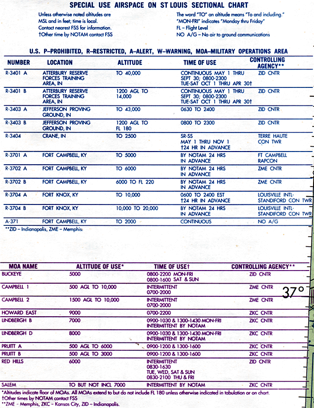
Special Use Airspace
|
Graphics for Special Use Airspace Sound Clip
Aeronautical Information Manual, Chapter 3, Section 4
Special Use Airspace
3-4-1. General
a. Special use airspace consists of that airspace wherein activities must be confined because of their nature, or wherein limitations are imposed upon aircraft operations that are not a part of those activities, or both. Except for controlled firing areas, special use airspace areas are depicted on aeronautical charts. b. Prohibited and restricted areas are regulatory special use airspace and are established in 14 CFR Part 73 through the rulemaking process. c. Warning areas, military operations areas (MOA's), alert areas, and controlled firing areas (CFA's) are nonregulatory special use airspace. d. Special use airspace descriptions (except CFA's) are contained in FAA Order 7400.8, Special Use Airspace. e. Special use airspace (except CFA's) are charted on IFR or visual charts and include the hours of operation, altitudes, and the controlling agency. 3-4-2. Prohibited Areas Prohibited areas contain airspace of defined dimensions identified by an area on the surface of the earth within which the flight of aircraft is prohibited. Such areas are established for security or other reasons associated with the national welfare. These areas are published in the Federal Register and are depicted on aeronautical charts. 
3-4-3. Restricted Areas
a. Restricted areas contain airspace identified by an area on the surface of the earth within which the flight of aircraft, while not wholly prohibited, is subject to restrictions. Activities within these areas must be confined because of their nature or limitations imposed upon aircraft operations that are not a part of those activities or both. Restricted areas denote the existence of unusual, often invisible, hazards to aircraft such as artillery firing, aerial gunnery, or guided missiles. Penetration of restricted areas without authorization from the using or controlling agency may be extremely hazardous to the aircraft and its occupants. Restricted areas are published in the Federal Register and constitute 14 CFR Part 73. b. ATC facilities apply the following procedures when aircraft are operating on an IFR clearance (including those cleared by ATC to maintain VFR-on-top) via a route which lies within joint-use restricted airspace.
c. Restricted airspace is depicted on the en route chart appropriate for use at the altitude or flight level being flown. For joint-use restricted areas, the name of the controlling agency is shown on these charts. For all prohibited areas and nonjoint-use restricted areas, unless otherwise requested by the using agency, the phrase "NO A/G" is shown. 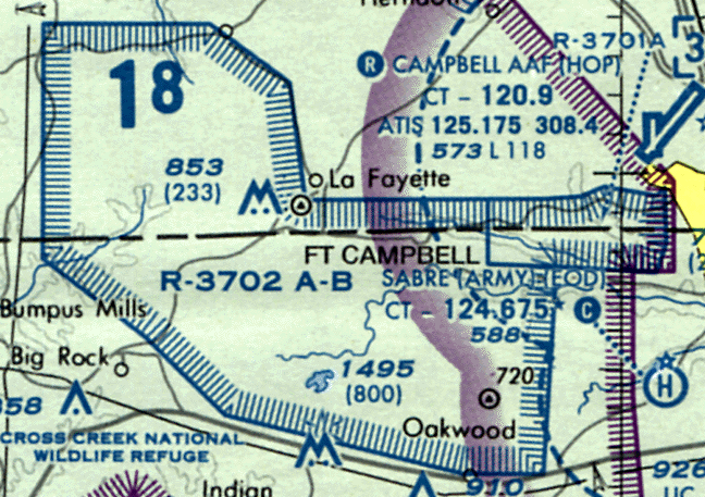
3-4-4. Warning Areas
A warning area is airspace of defined dimensions, extending from three nautical miles outward from the coast of the U.S., that contains activity that may be hazardous to nonparticipating aircraft. The purpose of such warning areas is to warn nonparticipating pilots of the potential danger. A warning area may be located over domestic or international waters or both. 
3-4-5. Military Operations Areas
a. MOA's consist of airspace of defined vertical and lateral limits established for the purpose of separating certain military training activities from IFR traffic. Whenever a MOA is being used, nonparticipating IFR traffic may be cleared through a MOA if IFR separation can be provided by ATC. Otherwise, ATC will reroute or restrict nonparticipating IFR traffic. b. Examples of activities conducted in MOA's include, but are not limited to: air combat tactics, air intercepts, aerobatics, formation training, and low-altitude tactics. Military pilots flying in an active MOA are exempted from the provisions of 14 CFR Section 91.303(c) and (d) which prohibits aerobatic flight within Class D and Class E surface areas, and within Federal airways. Additionally, the Department of Defense has been issued an authorization to operate aircraft at indicated airspeeds in excess of 250 knots below 10,000 feet MSL within active MOA's. c. Pilots operating under VFR should exercise extreme caution while flying within a MOA when military activity is being conducted. The activity status (active/inactive) of MOA's may change frequently. Therefore, pilots should contact any FSS within 100 miles of the area to obtain accurate real-time information concerning the MOA hours of operation. Prior to entering an active MOA, pilots should contact the controlling agency for traffic advisories. d. MOA's are depicted on sectional, VFR Terminal Area, and Enroute Low Altitude charts. 
3-4-6. Alert Areas
Alert areas are depicted on aeronautical charts to inform nonparticipating pilots of areas that may contain a high volume of pilot training or an unusual type of aerial activity. Pilots should be particularly alert when flying in these areas. All activity within an alert area shall be conducted in accordance with CFR's, without waiver, and pilots of participating aircraft as well as pilots transiting the area shall be equally responsible for collision avoidance. 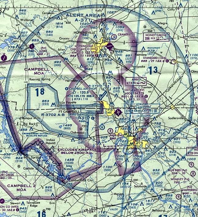
3-4-7. Controlled Firing Areas
CFA's contain activities which, if not conducted in a controlled environment, could be hazardous to nonparticipating aircraft. The distinguishing feature of the CFA, as compared to other special use airspace, is that its activities are suspended immediately when spotter aircraft, radar, or ground lookout positions indicate an aircraft might be approaching the area. There is no need to chart CFA's since they do not cause a nonparticipating aircraft to change its flight path.
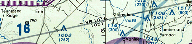
1. IFR Military Training Routes - (IR):
Operations on these routes are conducted in accordance with IFR regardless
of weather conditions.
2. VFR Military Training Routes - (VR): Operations on these routes are conducted in accordance with VFR except flight visibility shall be 5 miles or more; and flights shall not be conducted below a ceiling of less than 3,000 feet AGL. d. Military training routes will be identified and charted as follows: 1. Route identification. (a) MTR's with no segment above 1,500 feet AGL shall be identified by four number characters; e.g., IR1206, VR1207. (b) MTR's that include one or more segments above 1,500 feet AGL shall be identified by three number characters; e.g., IR206, VR207.
 |